New map: City of streams, city of pipes
This is a picture of the D.C. stream network as it appeared in the mid-1800s. This 2024 edition of the map provides a firmer vision of the past, bringing in more stream names and identifying old springs. It traces the modern-day sewers that carry runoff in place of vanished streams, and it more clearly shows the city’s topography, the bridge between past and present.
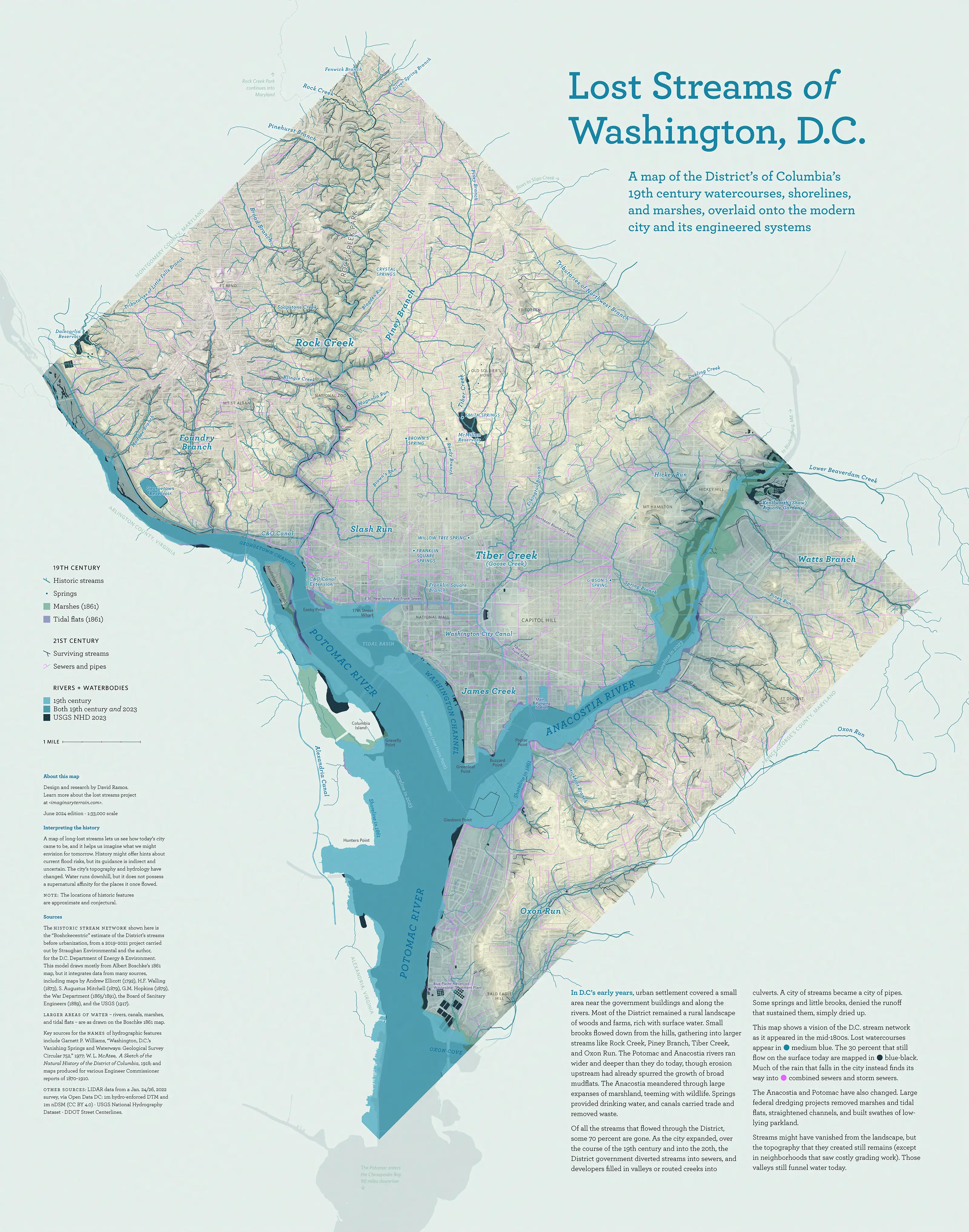
This map shows a vision of the D.C. stream network
as it appeared in the mid-1800s
In D.C’s early years, urban settlement covered a small area near the government buildings and along the rivers. Most of the District remained a rural landscape of woods and farms, rich with surface water. Small brooks flowed down from the hills, gathering into larger streams like Rock Creek, Piney Branch, Tiber Creek, and Oxon Run. The Potomac and Anacostia rivers ran wider and deeper than they do today, though erosion upstream had already spurred the growth of broad mudflats. The Anacostia meandered through large expanses of marshland, teeming with wildlife. Springs provided drinking water, and canals carried trade and removed waste.
Of all the streams that flowed through the District, some 70 percent are gone. As the city expanded, over the course of the 19th century and into the 20th, the District government diverted streams into sewers, and developers filled in valleys or routed creeks into culverts. A city of streams became a city of pipes. Some springs and little brooks, denied the runoff that sustained them, simply dried up.
Streams might have vanished from the landscape, but the topography that they created still remains (except in neighborhoods that saw costly grading work). Those valleys still funnel water today.
Lost streams project
There’s more about the District’s hydrologic history over on the streams project page, including photos, maps of individual subwatersheds, and links to source maps.
Sources
The historic stream network shown here is the “Boshckecentric” estimate of the District’s streams before urbanization, from a 2019–2021 project carried out by Straughan Environmental and the author, for the D.C. Department of Energy & Environment. This model draws mostly from Albert Boschke’s 1861 map, but it integrates data from many sources, including maps by Andrew Ellicott (1792), H.F. Walling (1873), S. Augustus Mitchell (1879), G.M. Hopkins (1879), the War Department (1865/1891), the Board of Sanitary Engineers (1889), and the USGS (1917). Larger areas of water – rivers, canals, marshes, and tidal flats — are as drawn on the Boschke 1861 map.
Key sources for the names of hydrographic features include Garnett P. Williams, “Washington, D.C.’s Vanishing Springs and Waterways: Geological Survey Circular 752,” 1977; W. L. McAtee, A Sketch of the Natural History of the District of Columbia, 1918; and maps produced for various Engineer Commissioner reports of 1870–1910.
Other sources: LIDAR data from a Jan. 24/26, 2022 survey, via Open Data DC: 1m hydro-enforced DTM and 1m nDSM (CC BY 4.0) · USGS National Hydrography Dataset · DDOT Street Centerlines.
June 2024 edition.